The Blue Ridge Parkway Road Trip: Shenandoah & Great Smoky Mountains National Parks

The Blue Ridge Parkway Road Trip Route
Start / End
Wanyesboro, Virginia to Cherokee, North Carolina
States Covered
VA
NC
National Parks
Great Smoky Mountains National Park & Shenandoah National Park
Total Distance
469 miles / 755 km
Suggested Days
3-5 (For just driving the parkway, budget three days. For more exploration around Shenandoah and Great Smoky Mountains National Parks, plan for at least five days.)
Suggested Seasons
Spring, Summer, Fall (The fall foliage along the Blue Ridge Parkway is some of the best in the country!)
#ThisIsMyRoute
Overview
The Blue Ridge Parkway road trip is an iconic American adventure that connects Shenandoah and Great Smoky Mountains National Parks. The route is 469 miles long and includes the most visited unit of the National Park system almost every year since 1946. While this route technically takes less than ten hours to complete, there’s no need to rush! I put together a slow-paced three-day road trip to fully explore this famous route. I definitely recommend extending your trip both before and after this road trip to make more time for Great Smoky Mountains and Shenandoah National Parks and everything in between.
Want to make this itinerary your own? The Blue Ridge Parkway road trip interactive map is perfect for planning your trip. Take your time, download a good playlist, and enjoy a leisurely road trip along “America’s Favorite Drive”.
A Few Tips Before Your Blue Ridge Parkway Road Trip
The Blue Ridge Parkway travels through remote sections of the Appalachian Mountains. Always ensure you start your day with a full tank of gas, and fill up frequently whenever you pass a gas station along your drive.
With the remoteness of this drive comes a lack of phone service and I always recommend saving both your directions and a few good playlists to your phone for times when you are without phone service. It also makes sense to bring a paper map for any technology malfunctions.
In the same vein, bathrooms are limited along the route so it’s a good idea to use the restroom as needed when passing through visitors centers or small towns during your drive.
DAY 1: SHENANDOAH NATIONAL PARK
Take the first day of your trip to explore Shenandoah National Park. I recommend checking out the below hikes and locations during your time in the park:
Skyline Drive is one of the most iconic destinations within the park, and features countless roadside overlooks as well as access to the park’s extensive network of hiking trails.
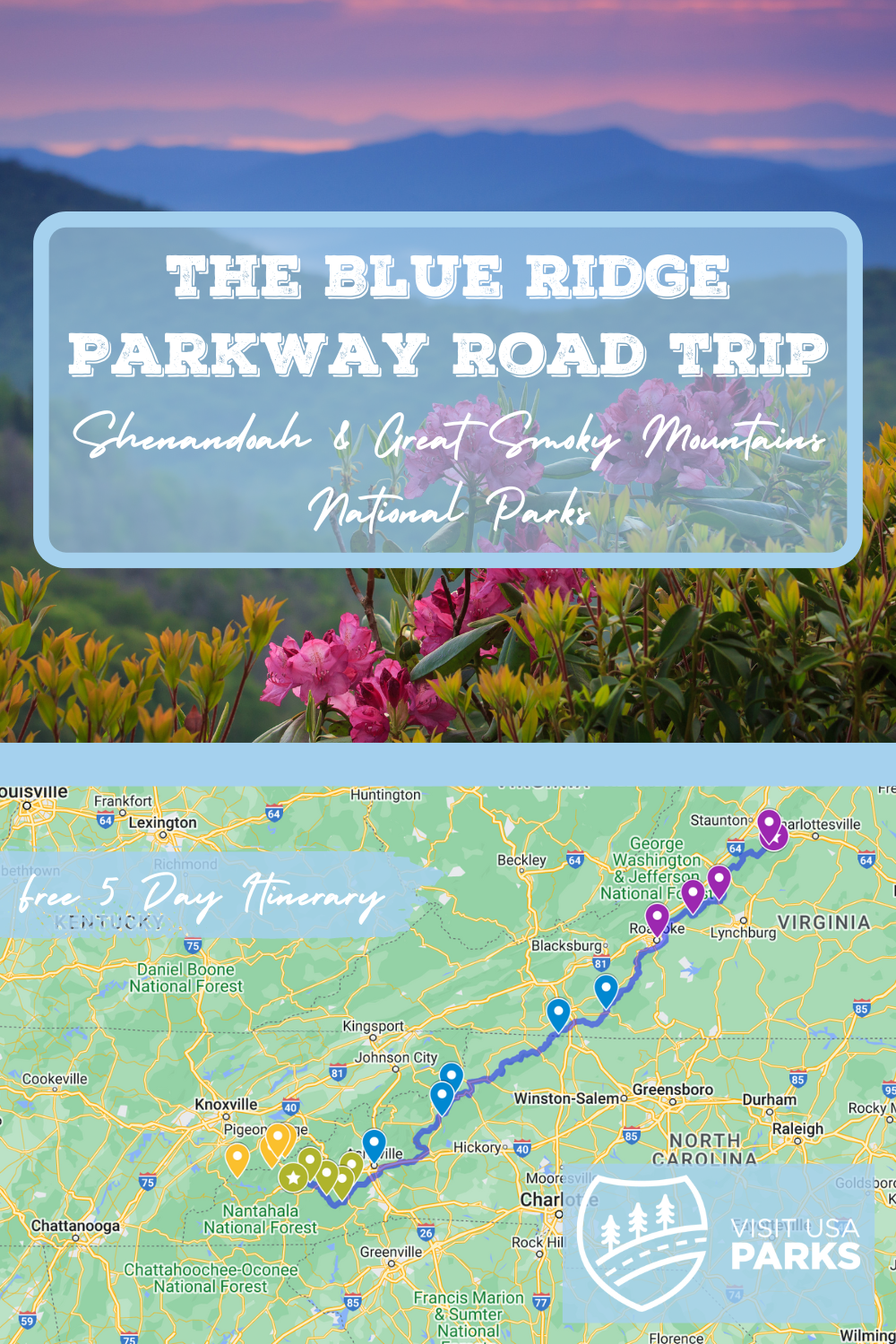
Mary’s Rock (mile 31.6 on Skyline Drive) takes hikers along the famous Appalachian Trail towards this picturesque rocky summit. Hikers are greeted by panoramic views of the Page Valley and the Northern section of Shenandoah National Park. This hike is 3.8 miles round trip, or you can take the slightly easier 3.4 mile route to the summit via the Mountain Pass Loop.
Mary’s Rock, Shenandoah National Park
Dark Hollow Falls (mile 50.7 on Skyline Drive) is one of the most traveled trails within Shenandoah National Park, and treats hikers to a stunning 70 ft waterfall surrounded by seemingly endless green trees. At only 1.6 miles, this trail is short but very steep – dropping a total of 583 feet to reach the falls, followed by hikers climbing that same elevation back to the parking lot along Skyline Drive.
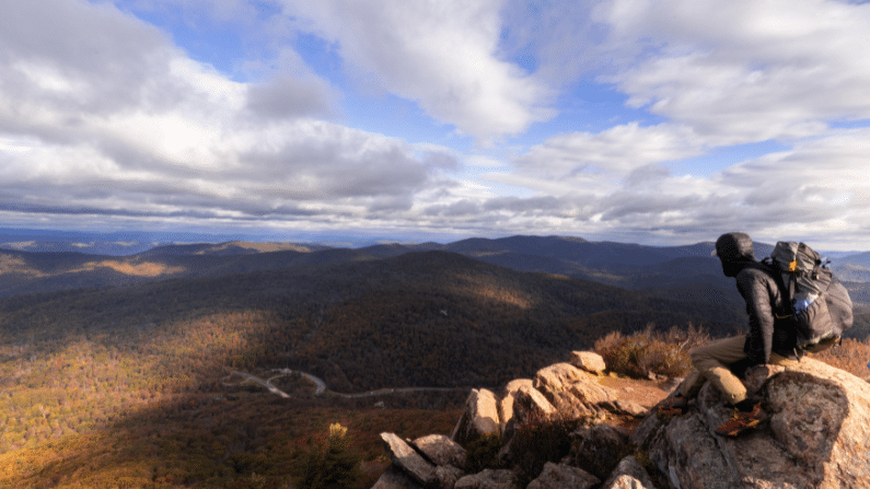
Bearfence Mountain (mile 56.4 on Skyline Drive) is my personal favorite hike within Shenandoah National Park. This 1.3 mile trail starts along a smooth section of the Appalachian Trail, and ends with a short rock scramble to the summit of Bearfence Mountain. The summit features 360° views and is one of the best spots in the park for both sunrise and sunset.
Bearfence Mountain, Shenandoah National Park
Old Rag is the park’s most famous hike, and offers stunning 360° views of the surrounding mountains.To limit large numbers of crowds and help preserve the area, day use reservations are required for all hikers on this route. Tickets can be purchased on recreation.gov.
End your day in Waynesboro, Virginia, and prep for your first official day on the Blue Ridge parkway tomorrow morning!
DAY 2
Total Daily Drive Time on the Blue Ridge Parkway: 3 hours / 170 miles
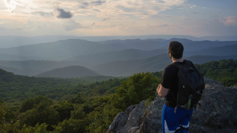
Start your road trip at the Blue Ridge Parkway Northern Entrance outside of Waynesboro, Virginia. Hop on the road – but don’t get too comfortable. Look out for your first stop at The Humpback Rocks Overlook at mile marker 5.8. Unlike many overlooks along the Blue Ridge Parkway where you can see the view within a few steps of your car, Humpback Rocks is a short trail (2 miles round trip) that takes hikers to a dramatic overlook along a set of jagged rocks. Take your time, and stretch your legs before the rest of your road trip.

Humpback Rocks Trail, Shenandoah National Park
After your hike, continue down the parkway and take your time stopping along the many roadside overlooks you’ll pass along the way. At mile marker 63, stop at the James River Visitor Center to learn a bit of Virginia history as well as a ton of information about the Blue Ridge Parkway itself.
Continue down the parkway to the Peaks of Otter trail, lodge, and restaurant at mile marker 86. Here, you can hop on the trail to Sharp Top Peak (3 miles round trip), and finish with lunch at the restaurant.
After filling up, continue down the Blue Ridge Parkway until you see signs for Roanoke, Virginia. Spend the evening checking out the city and staying at one of the many quaint Airbnbs or hotels in the area.
DAY 3
Total Daily Drive Time on the Blue Ridge Parkway: 5 hours / 210 miles
Head out of Roanoke and hop back on the parkway for another day of exploring. Today you will be driving along the most photographed section of the parkway – and it will be easy to see why. Again be sure to stop at as many overlooks as possible to take in the unique beauty of the Blue Ridge Mountains.
The first official stop of the day is Mabry Mills at mile marker 176 – a historic watermill with exhibits about life in rural Virginia. After exploring the area, continue heading south down the parkway towards the Blue Ridge Parkway Music Center at mile marker 213. Bluegrass music is vitally important to the history of the Appalachians, and this museum gives visitors an in-depth look at the history of the genre.

Views along the Blue Ridge Parkway
Hop back on the road – with your new Bluegrass playlist loaded up – and head south towards the famous Grandfather Mountain at mile marker 305. You can see the whole mountain from the marked overlook along the Blue Ridge Parkway, but I recommend taking the 20-minute (each way) detour to the Mile High Swinging Bridge located on Grandfather mountain. The footbridge is 228-feet long and stretches across an 80-foot chasm that’s more than a mile deep.
After Grandfather Mountain, head over to Linville Falls Trailhead & Visitor’s Center at mile marker 316. These three-tiered falls are the most famous in the Blue Ridge Mountains, and the steep walled gorge is known as the “Grand Canyon of the Southern Appalachians”. Take the Erwin’s View Trail (1.6 miles round trip) for four different overlooks of the falls, and leave some time to stop in the visitor’s center as well.
From here, it’s time to head to your home for the night in Asheville, North Carolina. Be sure to leave time to check out the city and eat dinner at some of its amazing restaurants or breweries.
DAY 4
Total Daily Drive Time on the Blue Ridge Parkway: 2 hours / 85 miles
Welcome to what’s known as the Pisgah region of the Blue Ridge Parkway – home to some of the highest points along the parkway and countless roadside overlooks. The finale of your road trip definitely saves some of the best views for last.
Since this is a lighter driving day, feel free to spend the morning exploring Asheville, North Carolina. When you’re ready to hop back in the car, drive down the Blue Ridge Parkway towards Mount Pisgah at mile marker 406. From here, hike the 1.6 mile Mount Pisgah trail to a bald summit that offers sweeping views.
After your hike, get back in the car for a quick drive towards Graveyard Fieldsat mile marker 418. This 2.3 mile Loop takes hikers to the 40ft Yellowstone Falls and is an easy stroll along man-made boardwalks.
It’s finally time for the long awaited highest point along our Blue Ridge Parkway road trip – at mile marker 431 be sure to pull over at the Hayward-Jackson Overlook, which is considered the highest point along the Blue Ridge Parkway at 6,053 feet above sea level. There is a picnic area here as well as a trailhead that serves as the starting place for a handful of hikes.
For the grand finale, consider stopping at the Waterrock Knob Visitor Center at mile marker 451 for sunset. Aside from a ton of interesting educational materials found inside the visitor center, the surrounding overlooks provide some of the best scenery in the area for golden-hour light. The Visitor Center is the highest building on the parkway, and is known for its unobstructed views of several major mountain chains in the Appalachians.
After enjoying sunset, continue along the parkway for another few miles until you reach Great Smoky Mountains National Park. If you are choosing to stay the night, I recommend staying in Cherokee, North Carolina.
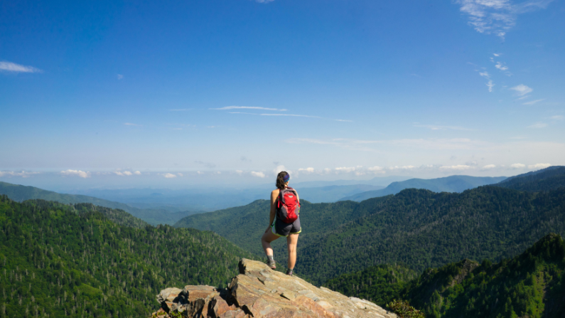
Great Smoky Mountains National Park
DAY 5: GREAT SMOKY MOUNTAINS NATIONAL PARK
Take the last day of your trip to explore Great Smoky Mountains National Park. I recommend checking out the below hikes and locations during your time in the park:
Charlie’s Bunion is one of the most famous hikes within Great Smoky Mountains National Park. Hikers follow the Appalachian Trail for an 8.6 mile round trip towards this large outcropping that looks like – you guessed it – a giant bunion. The formation was actually created by Mother Nature in 1925 when a forest fire burned most of the vegetation in the area. In 1929 a severe flood washed away any remaining soil and the bunion emerged in the aftermath. Sights from the bunion feature dramatic views of the rugged mountains that make up the National Park.
Clingman’s Dome is a 45 ft high observation tower with sweeping 360-degree views of Great Smoky Mountains National Park. The tower was constructed in 1959 and is ADA accessible with its sweeping 375-foot ramp for those in wheelchairs as well as for children in strollers. The tower is listed on the National Register of Historic Places, and is one of the most well recognized landmarks within the park.
Alum Cave Trail takes hikers to one of the most unique areas within the park. The trail features a mix of old growth forest, rugged rock formations. and ridgeline hiking that offers unobstructed views that stretch for miles. Alum Cave is actually more of an impressively tall cliff with a substantial overhang. It’s Incredibly scenic and provides excellent shelter for hikers caught in the summer rain storms that frequent the area.
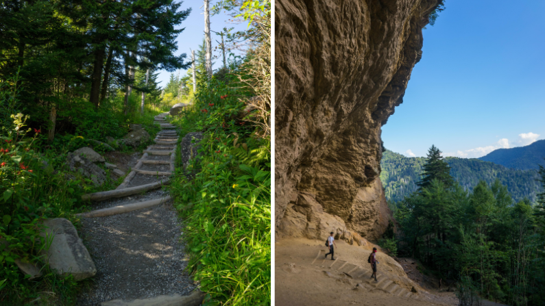
Shuckstack Fire Tower & Alum Cave Trails, Great Smoky Mountains National Park
Shuckstack Fire Tower follows the Appalachian Trail for a 6.6 mile round trip hike that offers hiker’s views of Fontana Lake and eventually reaches the iconic Shuckstack Fire Tower. The 60-foot tower was built in 1934 and is no longer in use by the Forest Service, however it is still available for recreational use by the public.
I recommend spending the night in Gatlinburg, or in one of the park’s many campgrounds. Beware of the prevalence of black bears in the region, and brush up on your bear safety tips before your visit.
Please note that this national parks road trip itinerary is a rough guide, and you may need to adjust the number of days spent at each location based on your interests and pace of travel. Additionally, availability of accommodations and camping sites may vary, so it’s a good idea to make reservations in advance, especially during peak travel seasons. Enjoy your adventure!
All photos in this article are courtesy of Colleen Goldhorn.
For updated information on Blue Ridge Parkway road closures due to hurricane Helene, check here.