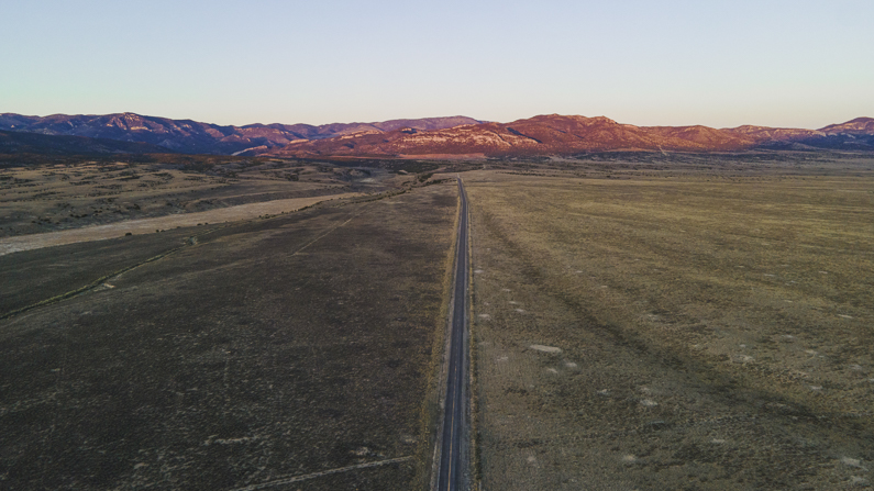
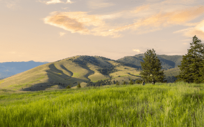
Stretching across the heart of the Mountain State, Highway 50 is in a league of its own–not just for its scenery and solitude (which there is plenty of), but also for its place in American history.
History of Highway 50
Beginning in 1860, Pony Express riders whisked mail across the state by horseback, carrying messages coast-to-coast in as little as 10 days. The forward march of progress (i.e., the telegram) quickly rendered the service obsolete, though the trail had been blazed and some of the relay stations along the route became permanent settlements. Prospectors seeking riches in the Sierra Nevada began using the corridor, then known as the Central Overland Route, connecting Carson City, Nevada, and Salt Lake City, Utah. Decades later, with the arrival of the automobile, it became part of the Lincoln Highway–America’s first transcontinental highway, dedicated in 1913.
Its isolation and long stretches of open road earned it the moniker, “The Loneliest Road in America,” from a 1986 LIFE magazine article. That particular writer was unimpressed (and in my opinion, over-dramatic). The author went as far as advising travelers to have “survival skills” before attempting the route. Having traveled the highway across Nevada (and back) myself, I can assure you no special skills are needed to survive; just a sense of adventure, a little planning, and a better attitude than a certain LIFE magazine contributor. Whether you’re a history buff or an outdoor enthusiast, there are plenty of surprises for the curious-minded traveler.
This story was created in partnership with Pony Express Territory.
Dayton to Fallon
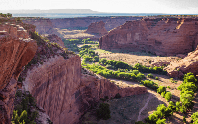
With a rough itinerary (and plenty of time for impromptu stops), I began my trek across The Loneliest Road in Dayton, Nevada, a short drive south of Reno on the western edge of the state. Here is where gold was first discovered in Nevada in 1849, putting the town on the map. You can find relics of the area’s mining history nearly everywhere you look, though none more obvious than the engineering feat that is the Sutro Tunnel.
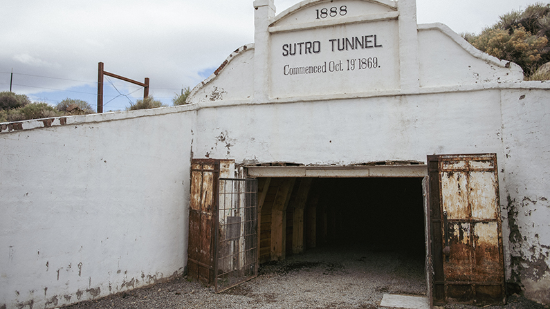
In 1869, an enterprising Prussian immigrant by the name of Adolph Sutro began digging a horizontal tunnel underneath the Comstock Lode–the first major silver discovery in the U.S.–eventually reaching the mines nearly four miles away, deep underneath Virginia City. The tunnel not only improved safety in the mines by providing ventilation and water drainage, but it was also used to remove ore by the ton. The tunnel was eventually abandoned when mining activity dried up, falling into disrepair. That is, however, until recently; enter the Friends of Sutro Tunnel, an organization dedicated to restoring the tunnel and other historic structures on the site. Several hundred feet (and counting) of the tunnel have been stabilized, allowing visitors to see it for themselves. Tip: advance reservations are required for tours.

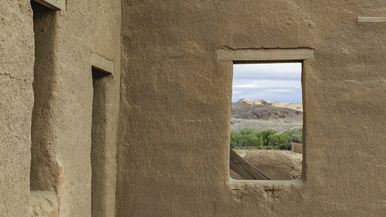
Continuing east, you’ll begin to encounter more remnants of past travelers, notably at Fort Churchill State Historic Park. Built in 1860, the fort offered protection for the Pony Express riders and other weary travelers, and during the American Civil War it was used as a supply depot for the Union Army. Up to 200 soldiers could be stationed here at one time, though with the end of the Civil War in 1869, the fort was abandoned.
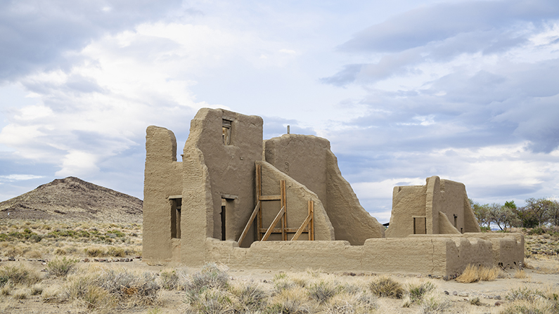
Today, the park still serves as a waypoint for modern travelers. Visitors can explore the preserved ruins of the fort, including adobe walls, barracks, and officers’ quarters, set against a backdrop of the rugged desert. The sprawling park also offers walking trails and opportunities for picnicking, hiking, and birdwatching along the Carson River.
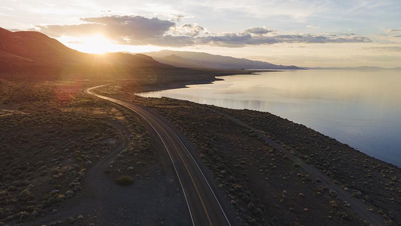
Before continuing east, take a slight detour to the north for a stop in Fernley. This small town is a popular stop for travelers on their way to the Black Rock Desert for the annual Burning Man festival, as evidenced by a growing public art display at the Main Street Art Park. This is also a great jumping-off point for exploring Pyramid Lake, located just north on the Pryamid Lake Paiute Tribe’s Reservation. Anglers have been known to hook into 40-plus pound Lahontan cutthroat trout here, while birdwatchers have the opportunity to spot migrating birds at the Anaho Island National Wildlife Refuge. Even if you’re short on time, I’d highly recommend a stop here for an epic sunset.
Just beyond Fernley lies Fallon, the last sizable town you’ll encounter for a few hundred miles. Known as the “Oasis of Nevada,” the area’s rich soil churns out juicy cantaloupes, grains, and fresh produce, all under the roar of Navy TOPGUN pilots (yes, that TOPGUN) training at Naval Air Station Fallon.
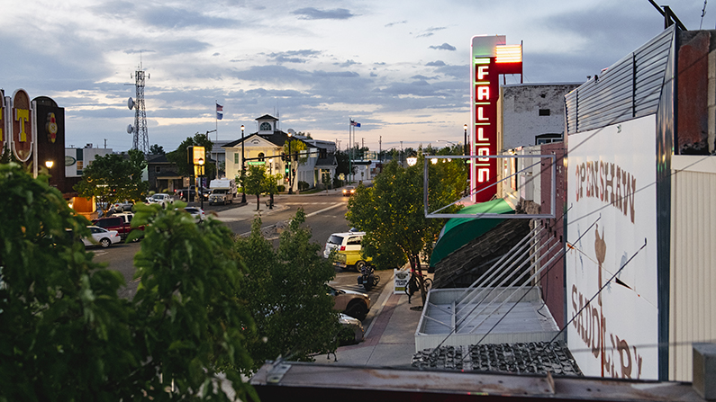
Fallon: The Oasis of Nevada
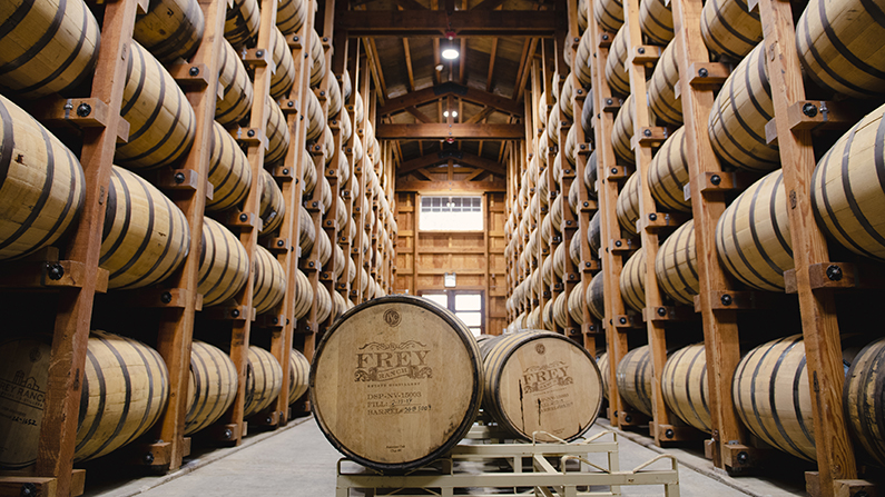
Beyond Fallon, creature comforts are few and far between, so I’d recommend treating yourself here. The Courtyard Cafe & Bakery serves up fresh, hearty breakfast and lunch, while The Grid pairs craft beers with pub fare at one location and operates a community-oriented market at another. For a truly unique “ground-to-glass” experience, head to the outskirts of town, where Frey Ranch Farmers + Distillers has been working the land for five generations. Specializing in single-barrel bourbon and rye whiskey, Frey Ranch is one of the few estate distilleries in the world. That means every speck of grain and kernel of corn that goes into your glass is grown on their 2-000 acre farm then mashed and distilled on site.
The distillery is open for tastings and tours on Saturdays, or try a local watering hole such as the Cranberry Cottage (if you can find it). Don’t be fooled by this quaint, unassuming vintage shop on Maine Street; after hours, check out the book shelf in the back of the store–you’ll be surprised where some light reading might take you.

In addition to human travelers, Fallon is an oasis for our feathered friends as well. The lakes and wetlands of the 79,000-acre Stillwater National Wildlife Refuge serve as a critical stopover for over 200 species of migratory birds, including the American white pelican. I’m no expert birdwatcher, but on a sunrise mission I managed to spot a flock of these graceful giants. With a wingspan of up to 10 feet, they’re among the largest birds in North America, rivaled only by the California condor.

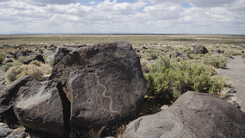
For a history lesson with a view, head to Grimes Point Archaeological Site, 10 miles outside of town. An easy, quarter-mile loop trail winds through a series of rock formations inscribed with petroglyphs, carved by Native Americans up to 7,000 years ago. From the petroglyph loop, another trail continues for a half-mile to an overlook with sweeping views. Keen observers will notice marks on the surrounding hills left by the shoreline of the ancient Lake Lahontan, while planespotters can watch Navy fighter jets landing and taking off from the nearby base.
The Loneliest Part of the Loneliest Road in America
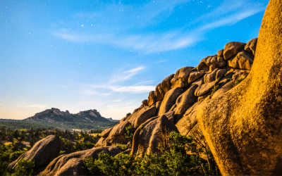
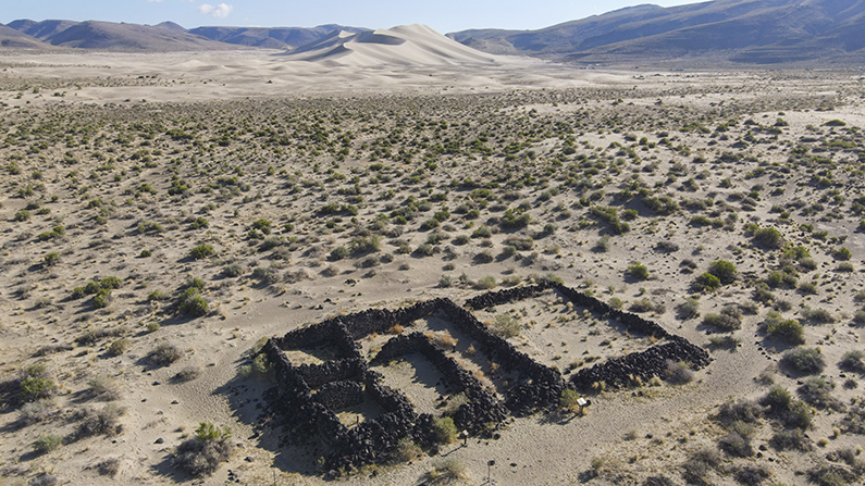
At this point, you’re still squarely in civilization; traveling east of Fallon is when you might start to notice the loneliness sinking in. The vastness is humbling, which I felt distinctly standing at the base of Sand Mountain, a sprawling expanse of wind-whipped sand dunes about 30 miles east. Today, it’s a destination for adrenaline junkies with dirt bikes and dune buggies, who make quick work of traversing this 600-foot tall obstacle. But at the edge of the dunes, the ruins of the Sand Springs Station serve as a stark reminder that travel here did, at one point, actually require survival skills. One visitor traveling by stagecoach in 1862 described his experience in a way that LIFE magazine might appreciate:
“The water near this vile hole was thick and stale with sulphury salts: it blistered even the hands. The station-house was no unfit object in such a scene, roofless and chairless, filthy and squalid, with a smoky fire in one corner, and a table in the centre of an impure floor, the walls open to every wind, and the interior full of dust.”
The station was eventually abandoned and lost to the dunes, nature erasing what little respite remained until the site was excavated in 1976. Now it’s one of the best-preserved ruins of a Pony Express relay station, one of 47 in Nevada. I climbed back into my air-conditioned car and continued on with a renewed appreciation for the sheer amount of grit it took to cross this epic, unforgiving landscape.
In the 260 miles between Fallon and Ely, the eastern hub of The Loneliest Highway, there are more ghost towns than ones with living souls. I’ll reiterate that survival skills are unnecessary, but I would highly recommend stocking up on snacks, water, and fuel at any opportunity on this stretch. So when you see an “open” sign lit up at a so-called “sagebrush saloon,” that’s your sign to take a break. Nevada is in a league of its own when it comes to middle-of-nowhere bars, and two of these historic watering holes happen to be in this stretch of near-emptiness. Middlegate Station prides itself on its Middlegate Monster Burger, and the Lucky Spur Saloon in Kingston (a 30-minute detour from Austin) happily serves locals and travelers alike. If you’re feeling lonely, these fine establishments are just what the doctor ordered.

Order the Middlegate Monster Burger at your own discretion, but a humble bacon cheeseburger was enough to hold me over for the next adventure–a long detour to Berlin-Ichthyosaur State Park. The name itself is a head-scratcher, befitting of the 225 million-year-old prehistoric swimmers that are fossilized here. The ichthyosaur—a carnivorous marine reptile and Nevada’s official state fossil—ruled the ancient ocean, hunting prey with its dolphin-like snout, growing up to 50 feet long. The largest concentration of these ancient predators are preserved in the park, with nearly 40 that have been unearthed.
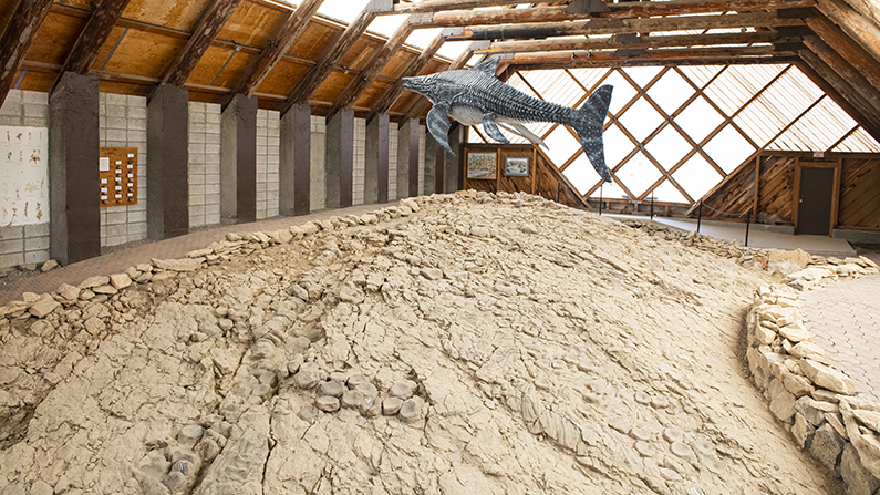
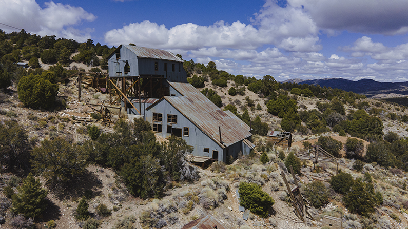
And Berlin? That would be the ghost town within the state park, nestled on the hillside with the remains of the Berlin Mine. The town supported a population of around 250 people during its heyday at the end of the 19th century, but was abandoned in 1911. If the miners ever did discover any fossilized dinosaurs, they were too struck with silver fever to mention it. That discovery was made in 1928, eventually prompting the state to preserve both sites in one truly unique park.
After making it back to Highway 50, Austin will be the next sign of civilization. This small, historic mining town was once Nevada’s second largest city, evidenced by the stately courthouse and three of the state’s oldest churches. If you want to bring a piece of Nevada home with you, stop by Jason’s Art Gallery (also known as Little Bluebird Turquoise) on Main Street. This family-run shop crafts handmade jewelry from two of Nevada’s most iconic resources–silver and turquoise–sourced from a local mine.

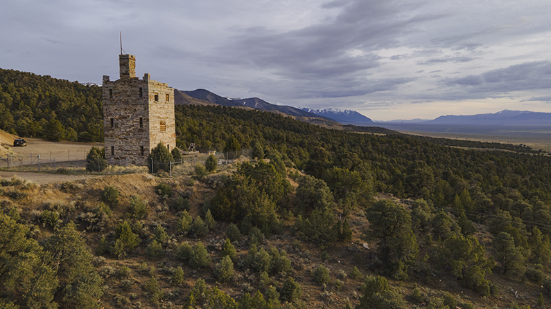
There are about a dozen (or more) places on this route that I’d describe as having “the best view,” but a five-minute drive from Austin offers one that’s a serious contender. Overlooking the Reese River Valley, the three-story Stokes Castle is a testament to the riches that were mined from the surrounding mountains, and also a great spot to catch a sunset.
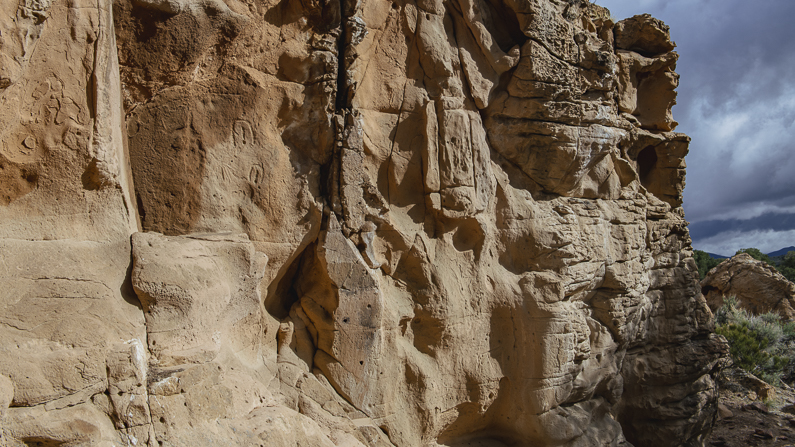
Continuing on from Austin, you’ll encounter more ancient art at the Hickison Petroglyph Recreation Area. This is a great spot for a picnic and a short hike to view the 10,000 year-old petroglyphs, as well as (more!) panoramic views of the Big Smoky Valley.
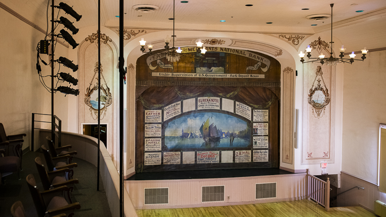
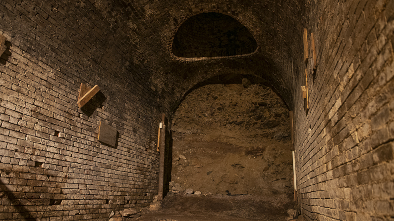
By the time you reach Eureka, you’ve made it through what I’d consider the loneliest stretch of Highway 50. Here you’ll find the best breakfast sandwiches on the route (Eureka Depot), as well as the well-preserved core of a once-booming mining town. On the surface, Eureka presented itself as a well-mannered, upstanding slice of civilization, complete with an opera house. Beneath the town, however, a different story emerges; one of bootlegging, gambling, and business of a seedier nature. At one point, nearly two miles of tunnels sprawled underneath the town, equally serving the debaucherous and those just wanting some peace and quiet. Much of the system has collapsed, though you can book a tour to see the remaining passageways.
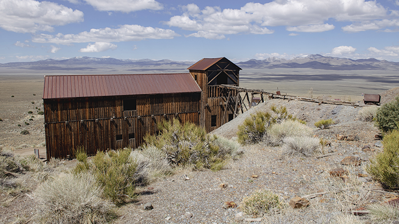
On your way east from Eureka, you’ll pass by yet another ghost town, Belmont Mill, that is well worth the detour. Located 10 miles south of the highway down a dirt road, this one feels truly off-grid, with no modern infrastructure or interpretive signs–just a remarkably well-preserved mill site. As the story goes with most ghost towns, Belmont Mill was abandoned nearly as quickly as it was built, another casualty of the boom-and-bust cycle. There’s no one here to vouch for your safety, so tread lightly, and as always, be respectful of the site and leave it the same way you found it.
Surviving ‘Til the Bristlecone End
Reaching Ely, you’ve nearly traversed the entirety of the Loneliest Road. Celebrate your survival with a cocktail and a meal at JT’s Steakhouse, which serves a rotating, seasonal menu featuring beef raised on the family ranch nearby. After spending several days on the road, Ely is the perfect spot to post up for a few days to explore the area. Here you’ll find one of the most unique museums in the state–the Nevada Northern Railway Museum. Designated as a National Historic Landmark, the museum offers hands-on experiences for visitors, including operating a historic steam locomotive.

Ely is also a destination for outdoor enthusiasts, offering ample opportunities for hiking, mountain biking, paddling, fishing, and golfing (both the traditional and disc variety). If you talk to locals, one of the most exciting recent developments is the return of Cave Lake, the namesake reservoir of Cave Lake State Park. In 2021 the lake was drained in order to repair the 1930s era dam–a costly, but necessary decision. As of my visit in May of 2025, the rehabilitation of the dam and lake was complete, with boaters enjoying an evening paddle and anglers casting for trout.

From Ely, you’re only about an hour’s drive away from the eastern terminus of the Loneliest Road. Round out your mining history chops on the way with a stop at the Ward Charcoal Ovens State Historic Park, an 1870s-era set of stone kilns about 20 miles south of Ely. These 30 foot-tall, beehive-shaped ovens produced the charcoal that fed the region’s smelters and are some of the best preserved such ovens in the state.

Nevada’s Only National Park
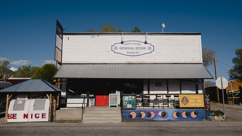
Upon reaching Baker, you’ve officially survived Highway 50, America’s loneliest road. Congratulations! And here you’re treated to Nevada’s tallest peak, located inside of Nevada’s only national park. You’ll catch views of the 13,167 foot-tall Wheeler Peak en route to Baker, but the best views are from within Great Basin National Park. By now you should be hard-wired to be prepared, but if you need a resupply of snacks, freshly brewed coffee, or other provisions, make a stop at the Bristlecone General Store.
The 12-mile Wheeler Peak Scenic Drive ascends to over 10,000 feet, with ample hiking trails and scenery along the way. As you climb above 8,000 feet, you’ll begin to encounter Great Basin Bristlecone pines, known as one of the longest-living organisms on the planet. The scenic drive is a fitting end to this epic road trip, literally ending the route on a high note.

The Truth About Highway 50
If LIFE magazine is to be believed, Highway 50 is, “totally empty,” adding, “there are no points of interest. We don’t recommend it.” If you’ve taken the time to explore, learn about the route’s rich history, and make friends along the way, you’ll know that it couldn’t be further from the truth.